Nature Reserves in The Occupied Golan-The environment in the service of land control policy-
Dr. Nazeh Brik
29.11.2021
Introduction:
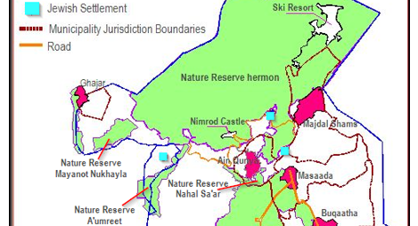
The June War of 1967 ended, with Israel taking control of an area of 1,260 square kilometers of the Syrian Golan Heights. About 60 square kilometers were returned to Syrian sovereignty in 1974 (Beger Gidon). Today, Israel controls 96% of the area it still occupies (1,200 square kilometers), which its ownership belonged to the Syrian state and the residents of hundreds of villages that the occupation forced demolished and expelled their residents outside the borders of its control. The remaining area (4%), still under the ownership of the five Syrian villages (Majdal Shams, Buqaatha, Masaada, Ain Qinya, and Ghajar), which were not affected by displacement and destruction. All these villages are located in the north of the Golan.
Israel defines the territory under its control as “State land”. Part of these lands have been placed at the disposal of the army and are used as training fields and for the establishment of military out posts. The largest part of the occupied lands was allocated to serve the settlement project (establishing settlements and developing the settlers' economic structure), another part was identified as nature reserves or national parks.
Releated Posts